
Chapter 1 - The Beginning
Section II. The Beginning
What was to become Bellingham was, in the 1600's, an unnamed tract of land to the east of Mendon and west of Wrentham. It belonged, below the Charles River, to the Town of Dedham. The area, although plentiful in water with the Charles River to the north and the Peters River to the south, was not good farmland. Heavily wooded throughout, the land was stony, and where not rockladden, it was wet. The man made lakes that exist today, Lake Hiawatha and Silver Lake, were large swamps, as were areas such as Box Pond, created later for mills. With many more bountiful areas to settle, Bellingham was neglected. Travelers passed through, few settled.
In 1636, the settlers in the southern part of the Massachusetts Bay Colony, north of Plymouth, sent the following request to the Colonial legislature:
"Inhabitants petition the General Court to certify to them & their heirs of a formal grant of a Plantation above the falls General Court grant the 10 of the 7 month 1636. the above petition as followeth, that the petitioners enjoy all that land on the easterly and southerly side of Charles River not formerly granted to any town or particular person; & also to have 5 miles square on the other side of the River. That the Town shall bear the name of Dedham."
Shortly thereafter "The General Court Grants the 10th of the 7th month 1636 the above Petition as foloweth,
"That the above Petitioner enjoy all that land on the westerly and sotherly side of Charles River not formerly Granted to any other Town nor Particular Person and also to have five miles square on the other side of the River."
"That the Town shall Bear the name of Dedham."
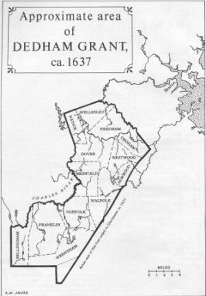 Most of the land to be called Bellingham was originally a portion of Dedham. The town of Mendon (including the present Blackstone) was chartered in 1666, and thereafter provided the western boundary of the area. The area became more defined as the towns surrounding were established: Wrentham (including the present Franklin) to the east in 1673; Sherborn (including the present Milford) to the north in 1674; Medway (originally part of Medfield) in 1713; and Attleborough (including parts of the present Cumberland and Woonsocket) to the south in 1694.
There is no indication that the Indians found the area to be livable before the English invasion of Massachusetts Bay. The few ancient artifacts found within the Town have not been consistent with long term settlements. Arrowheads, shards and other small Indian items have been found at various times in the Beaver Pond area, near Wrentham Road and near Silver Lake. They are not so numerous or of the type to indicate large permanent settlements.
Despite this, the area was involved in the dispute with the Indians called King Philip's War. King Philip was a member of the Nipmuck Indian tribe.
"King Philip claimed to own the land in Dedham, and in 1669 he received twenty two pounds eight shillings for that part which lay beyond Wrentham, later the principal part of our town. Probably men went there for meadow hay in summer, as they did to Wrentham. If any early settlements were made, they must have been abandoned when the people of Wrentham deserted their homes and took their families to Dedham; the Dedham selectmen had been warned by the General Court in 1673 to prepare for an Indian War."
In April 1671, a man named Zachary Smith was found dead in "Dedham Woods". Three Indians who had passed through the area were arrested, tried and convicted in court and executed on the gallows on Boston Common. The heads were then cut off and placed upon pikes in the tradition of the times. The father of one of these Indians, named Matoonas, was later involved in an attack on Mendon on July 14, 1675. Later he surrendered and was hanged and his head placed upon a pike opposite the area his son's had adorned. The Puritans were not sympathetic to his loss.
King Philip's War continued from about June 1675 until his death in August 1676 at the hands of local militia. His body was beheaded and quartered. His head was placed on a pike and displayed in Plymouth for nearly 25 years. During his short-lived reign he succeeded in uniting nearly every tribe from Maine to Connecticut. The war was fought over an area nearly two hundred miles in length. Major battles were fought in the towns surrounding Bellingham, but there is no evidence of any battle within the present confines of the Town.
While there may have been individual incidents, there were no further Indian uprisings in the area. The native population was scattered, its lands "purchased" and its inhabitantds pushed west. Proscelatizing ministers treated with the Indians not the farmers and shop keepers who came to inhabit the area. Despite that, the early houses were constructed with hidden rooms or other protection from the Indians. It is unlikely they were ever used in Bellingham.
Because of its geographical location, settlers traveled through Bellingham to get to more fertile areas to the west in Mendon or stopped just before to settle in Wrentham. A roadway across what later became the northern portion of the Town was crudely laid out by use. This was called The Country Road, later the Hartford Turnpike and now, Hartford Avenue. A second road led through the Town from Wrentham to Mendon. Its location does not seem to have survived in its old form. Other crude paths led into what is now South Bellingham. They were paths of convenience, rather than surveyed, constructed roads. Portions of these roads probably still exist, long buried under the macadam pathways of today.
With abundant and more fertile land to the east and west, no one settled in between. According to Partridge, there may have been a fort or house of refuge from Indians just north of the North Bellingham Cemetery. There is no other record of such a place however.
The church was the focus of each settlement. Churches were constructed in Mendon and in Wrentham. With travel difficult, getting to Church for services was certainly easier the closer the settled land was to the Church. Not to go to church was considered heresy.
The land in Bellingham was examined by two men sent by the Dedham Selectmen in 1691. They reported "Jan ye 4th 1692 ye land neer Mendham and Wrentham is not worth ye laying out in a Devident" (Division).
"The proprietors of the common or undivided lands of Dedham" met on June 7, 1698, to discuss the waste land to the west. They were informed by a committee apparently appointed to look at this area that it contained an estimated 2100 acres. It was agreed to draw lots of about 100 acres each. At this point "Jacob Bartlat did move for liberty to take upon his proportion in the place where he has Sat down & made Sum Inprovement this was voted provided convenient highways be reserved. Nicolas Cook likewise moved...to take up about fourty acres of land in part of his proportion neer his own land this was voted."
"The first land bought in Bellingham that was Dedham was purchased in 1696 by a man who believed that that government is best which governs least, and whose first public religious duty was to protest against the forms of the church." Jacob Bartlett was the son of John Bartlett, believed to have been one of the richest men in Massachusetts Bay Colony in his time. The father resided in Weymouth and later Mendon. In 1684, his inventory amounted to thirteen hundred pounds.
Jacob probably sought solitude and freedom to do and think as he wished in the wilderness that he purchased. He was a Quaker and probably felt it easier to practice his religious beliefs away from the other settlers. "The first lot of land laid out in that part of Dedham lying west of Wrentham & East of Mendon was 35 acres of land to Jacob Bartlet, who had settld on sd land before" This lot was laid out about 1684 but was not described in any record until 1713.
In fact, this first purchase from Dedham actually lies in what is now East Woonsocket, Rhode Island. Colonial bounds were not well established for many years. Only in 1846 was that area finally placed in Rhode Island colony. Jacob Bartlett later purchased for five pounds, in 1696, "nine cow common rights undivided in the common land between Wrentham and Mendon" from James Albee of Mendon.
"Cow common rights" were rights held by a settler in the "Common Land" (that land not yet divided off to an individual) and the right to graze his animals in that area. These rights were traded and sold the same as land by the settlers into the nineteenth century.
Bartlett appears to have been a very private person. No records have been found of the birth of his children. It is known that he had a son, Joseph, to whom he deeded his homestead in 1738. A second son Abner, is shown as having married Abigail Arnold in 1734 (she died in 1815 at the age of 104). A third son, Jacob Jr bought a part of his father's farm and made scythes.
Jacob Bartlett sought religious freedom and for many years he was able to have it, within the context of his day. However, even in the wilderness he found intolerance. Later in life he found himself in Boston jail for failure to pay taxes for ministerial services. His stay was short, however.
"Two traditions of Jacob Bartlett have been found in the vicinity of his farm, now East Woonsocket. He had a sick child one very cold day in winter, and walked across the Great River several miles to Sayles Hill for some milk, and found the cow frozen dead. Again when a dear child of his died, he kept the body so long that one of the neighbors knocked on his door one dark night and said, "Jacob, Jacob, bury thy dead." The answer was, "Yea, Lord, I will bury him in the morning.""
The family burial ground had about two dozen rough stones left in 1879, and the old house then stood at the end of a lane from the highway, supposed to be one hundred and eighty three years old. When Cumberland became part of Rhode Island, none of this family was left in Bellingham. No record exists that any member of the family ever actually lived within the present boundaries of Bellingham, although he was deeded land by the Bellingham proprietors that was within the present town.
The second recorded settler in Bellingham was Nicholas Cook. Like Jacob Bartlett, his father, Walter Cook, moved from Weymouth to Mendon. Also like Jacob, Nicholas did not practice the established religion, claiming to be a Baptist. In 1685, Walter and his sons, John and Samuel, headed a temperance society, promoted by Rev. Grindal Rawson, a Puritan minister of the time and the son of another person instrumental in Bellingham's beginning. Thus it is likely Nicholas adopted his religious beliefs after some personal soul searching.
Nicholas Cook was born in 1660. He married Joanna Rockwood in 1684. After her death, he married Mehitable Staples in 1712. Both were from Mendon.
While it is likely Nicholas Cook settled before that time as noted above, the first recorded land transaction was in 1705, when land was laid out for him east of the Great River (Blackstone River) and on both sides of the Peters River. In 1713 he deeded land to his son, Nicholas Jr, that was partly in Mendon and Bellingham. At the time, Mendon extended from the northern most to the southern most point on the westerly boundary of what was later to be Bellingham (including what is now Blackstone).
Nicholas was not wealthy. In 1706, the Dedham records show that "Nicholas Cook in behalf of himself and several of his neighbors, being new beginners and some of them very poor," asked relief from town taxes for two years. It was granted.
Nicholas Cook was active in the formation of the Town of Bellingham. He died December 1, 1730, at the age of 71. His burying place is still to be seen in the *South Bellingham Cemetery. Upon his death he had an inventory that amounted to 1200 pounds, 882 of which was in real estate. His bequeaths of 72 acres to his eldest son Josiah, 105 acres to Nicholas Jr., and 37 acres, including the homestead, to his youngest sons, David and Noah, show the accumulation of property available to a hardworking farmer of the time.
*Please note the “Scott Cemetery” is located on Center St and is sometimes referred to as the “South Cemetery”