
Bellingham's GIS
Welcome to the Town of Bellingham's GIS Website.
We support DPW Operations and Assets while providing assistance to all other Town departments
mapping and data needs.
* Please check back frequently as updates are coming.
Overview of GIS:
Geographic Information Systems(GIS) started being developed in the late 1960's and is
the digital version of cartography. Cartography the art of map making and surveying combined
have been traditionally used to make a map. This was often labor intensive and
encompassed many hours if not days to generate. With GIS, we can update maps daily
and with better accuracy. By using tools of Global Positioning Satellites(GPS),
our phones and accurate survey equipment, we can collect more real world assets with
greater accuracy and precision. For instance, items you see in everyday life such as streets,
fire hydrants, houses, etc, to name a few can be mapped in layers and styled or displayed
on maps for print, web and cloud. Together these asset types can be used to better serve
residents and communities.
What is GIS?
GIS is a system of hardware, software, data, analysis and maps. The computer, phone,
tablet, GPS or remote sensor to collect and manage GIS. Software comprises the
mapping software, ArcGIS or AutoCAD among others to use the data and store it.
The data is everything in the built world collected per it's type, like points for
hydrants and signs, polygons for parcel boundaries and building footprints, and
lines for street centerlines and water/sewer pipes and many others. Data can also
be in tabular format and linked or joined to these layers for further information.
Where analysis comes in, you can overlay water main pipes with parcels and perform
a buffer analysis to see if water is near your property. You can also select parcels on
a street and use a nearest function to find water and sewer nearby. These can all
be mapped for display or pushed to a web map.
History of GIS use in Bellingham:
GIS has been used since the late 90's here in Town. Many real world items can be mapped
and displayed on maps or used in analysis. Massachusetts GIS has data that's been developed
for state and municipal use since the 80's.There have also been 'fly-overs' to digitally collect
data from the air. Typically, data collected are: edge of pavement(road asphalt width), driveways,
buildings, water bodies, and important structures around town. There are printed maps around
town hall and on our website that have been produced with Bellingham's GIS or data.
How does Bellingham use GIS, you ask?
Well it's been an integral part of the town since 1998 and is widely used by the DPW,
Assessing, Planning/Zoning and Conservation Commission. We use GIS to create large
scale full color maps, for powerful database management capabilities, engineering
planning and analysis, and to keep our water/sewer/stormwater assets up to date.
Up to the present, we've been building the data layers and insuring accuracy based upon the
layer type. Meaning, some layers need more accuracy than others. For instance, water pipes
and water gates need a higher level of precision than zoning boundaries(which generally follow
your property line).
We are the data editors for the MapsOnline link on this page. We are continually editing the data
for location and attribute accuracy. Each town department will own their data, but can be
viewed/shared by all departments and the public.
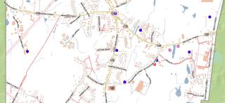
See some examples below of how GIS is used in Bellingham.
Online: Roads Nov22
Current web/GIS mapping in town:
For property/parcel information, click here: Maintained by the Assessors office.
(click the Magnifying glass on the left side to search. Or scroll in and pan around the map.)
https://www.axisgis.com/BellinghamMA/
To find out information about your house or business, click here:
(To get measurements, click the Map Info on bottom right of map window. Then, click either of the rulers for area or length.)
https://www.mapsonline.net/bellinghamma/
Current static maps you may download, click here: PDF format
https://www.bellinghamma.org/zoning-board/pages/bellingham-maps/
Please feel free to contact me with any questions.
David R Ahnert - GIS Coordinator
Update: 12/19/23
| Attachment | Size |
|---|---|
| 1.2 MB |